Top motorcycle routes in Greece
We love travelling, and definitely we love traveling by motorcycle. We enjoy riding through beautiful vistas and landscapes. We love the freedom and how connected we feel to our surroundings on a bike. Once you've started discovering new places/people/cultures on two wheels, adds an existential dimension to yourbeing-in-the-world and opens a new horizon in the inner temporality.
Greece is among the favorite motorcycle destinations for a good reason. This unique, mountainous, peninsular offers a great diversity of beautiful paths. Every corner leads to a new experience. Ideal for motorcycle riders who are avoiding flat highways and searching scenic roads to allow them access to the most remote locations.
Here is a small list of selected routes that may help you organize your trip. The list is indicative and is only used for sharing information by fellow motorcyclists who have travelled all over the country and think of these routes as the most notable. Think of it more as a starting point than anything else and make your personal adjustments according to your own travelling plans and needs. Every route has a road photograph and a google map's link. In some routes video footages are included as well. Few comments about the routes will be added in the future including some points of interest such as old bridges, canyons, traditional settlements, historical monuments etc. This is an open list after all and you are free to comment or propose modifications.
Few words about the country.
In English it is referred to as Greece but locals call the country Hellas or Ellada. Located strategically in Southern Europe at the crossroads of Europe, Asia, and Africa. Greece consists of a mountainous, peninsular mainland jutting out into the sea at the southern end of the Balkans, ending at the Peloponnese peninsula (separated from the mainland by the canal of the Isthmus of Corinth). Eighty percent of Greece consists of mountains, of which Mount Olympus, the mythical abode of the Greek Gods, is the highest, at 2,917 m (9,570 ft).
Mainland contains a number of lakes and wetlands and is dominated by the Pindus mountain range. The Pindus range continues through the central Peloponnese. This vast complex of mountains, peaks, plateaus, valleys and gorges traverses the Greek mainland from the Northwest to the Southeast. Its length reaches almost 230 kilometers and its largest width is 70 kilometers. Pindus is characterized by its high, steep peaks, often dissected by numerous canyons and a variety of other karstic landscapes.
Also, Greece has the longest coastline on the Mediterranean Basin and features a vast number of islands. Crete is the largest and the most populous island; Euboea, separated from the mainland by the 60m-wide Euripus Strait, is the second largest.
Climate
The country has considerable climatic variation. It is primarily Mediterranean, featuring mild, wet winters and hot, dry summers. The Pindus mountain range strongly affects the climate of the country, as areas to the west of the range are considerably wetter on average than the areas lying to the east of the range. The mountainous areas of Northwestern Greece as well as in the mountainous central parts of Peloponnese feature an Alpine climate with snowfalls during the winter.
History
Greece has a rich legacy and traces its roots to the civilization of Ancient Greece. This is partly reflected by the 17 UNESCO World Heritage Sites located in Greece, ranking it 6th in Europe and 13th in the world.
...
Το top μέχρι στιγμής με το υλικό που υπάρχει (θα ενημερώνεται κάθε φορά που θα προστίθεται κάτι νέο):
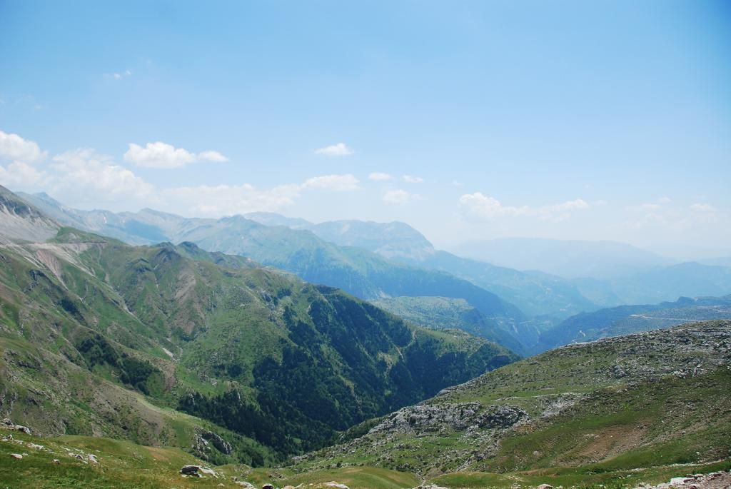
1. Baros Pass
Google Map: Ανήλιο - Χαλίκι - Μπάρος - Καλαρρύτες - Μονή Κηπίνας - Κέδρος - Ιωάννινα (Χαρακόπι)
Geographical region: Kalarites Zone, Epirus, Ioannina, Mt Athamanika or Tzoumerka
The Baros Pass is a spectacular high mountain road, reaching the top of the pass, at an elevation of 1,905m above the sea level, located on the Kalarites zone.
The pass is being improved the last years, with some asphalt works. This road is usually open all year, but it can be closed when the access is not cleared of snow.
The road includes some steep sections, without market central lines, very narrow, impassable for 2 cars at the same time and without protections and guardrails.
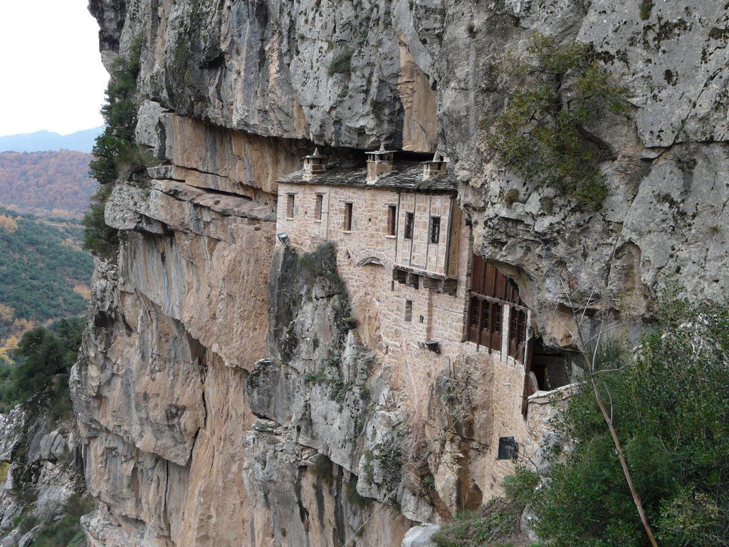
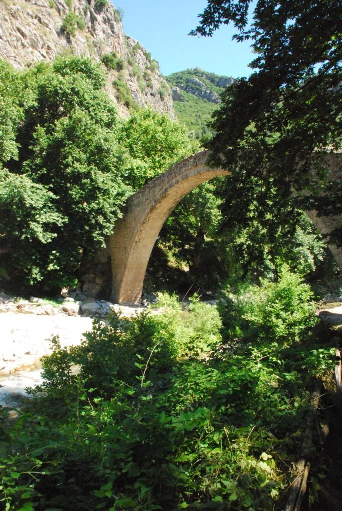
From Anilio to Chaliki the road is narrow with paved surface in a rather bad shape in some points. However the scenery is astonishing as the road winds through a beautiful forest in the most part, reaching at the altitude of 1600 m. where the alpine scenery takes place and gets spectacular. After about 7km from Chaliki village (alt 1100m) the road is forked (turn on the right to continue your trip through the Baros pass). In 2km from the junction you can stop to the monastery of “Panagia Galaktotrofousa” and enjoy the view. From this point and for the rest 1750m starts a twisty roller coaster, which no doubt will blow you away. Always watch for loose gravel and especially the last 200m. For the next 10km you are moving on a much slower pace because of the condition of the road until you reach at Kalarites village where you can stop for a hot coffee or a goody. You continue to ride downhill until you reach to the iron bridge. Next to it you will find the old stone bridge of “Filou” or “Tortouri”. After about a kilometer as you will pass a dark tunnel you will reach to the old monastery of “Kipinas” (1204) built in the rock. A stop and a tour in the interior are highly recommended.


Video by ckalfas:
Points of interest:
- Anilio Metsovou (village alt. 1060)
- Anthousa Panagia Galaktotrofousa (chapel)
- Chaliki Trikalon (village alt. 1160)
- Kalarites (village alt. 1120)
- Stone bridge "Filou" or "Tourtouri"
- Iera Moni Kipinas (Monaster)
2. Kefalonia Ionian Island
Google Map: Κεφαλλονιά από την παραλία του Μυρτου έως τον Ασσο μέσα από το βουνό
Geographical region: Ionian Islands, Kefallonia
Cephalonia or Kefalonia, is the largest of the Ionian Islands in western Greece.
You don't want to miss Kefalonia’s Magnificent Scenic Drive. Kefalonia, by its nature, is a mountainous island and therefore, many of its roads, whether coastal or inland, will have some bends, gradients and drop offs to one side or the other. The road through the mountain has excellent barriers all along it and it isn't very narrow. The traffic isnt busy either. Take your time, stop often for the views and enjoy. Be carefull about rockfalls or passing goats.

Points of interest:
- Myrtos Beach (http://en.wikipedia.org/wiki/Myrtos_Beach)
- Assos (coastal village)
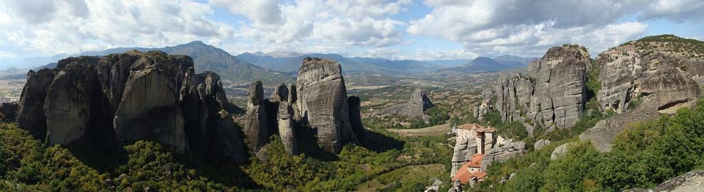
3. Καλαμπάκα - Περτούλι - Πύλι
Google Map: Καλαμπάκα (Μετέωρα) - Μονή Τιμίου Σταυρού - Περτούλι - Πύλη
Geographical region: Θεσσαλία, Πίνδος, ΝομόςΤρικάλων
Photo Διαδρομής:
4. Kallikrate's Pass and Aradena Gorge
Google Map: "Πέρασμα του Καλλικράτη" και Φαράγγι Αράδενας
Geographical region: Crete Island, White Mountains, Chania
The road between Kallikratis and Kapsodasos is a sharply winding and precipitous ascent in a a steep and narrow zig-zag road in southwest Crete, Greece.
The intresting part of the road (11km long) starts in Kalikratis, a small mountainous village in Sfakia municipality, southwest Crete, at the foot of the White Mountains (Lefka Ori) at an altitude of 750m above sea level and .
The road was asphalted in 2006 but it's very narrow. The recently paved road that runs through Kalikratis gorge is scary bumpy, small and empty, without barriers but with great views of Libyan (Southern Cretan) Sea.


Video by yns:
Points of interest:
- Aradena Gorge
- Bridge Vardinogiannis (the 2nd highest bridge for bungee jumping in Europe)
5. Ο γύρος της Θάσου
Geographical region: Ανατολική Μακεδονία, Νήσος Θάσος


Video by Παναγιώτης Κ.
6. Ο γύρος το Πάρνωνα
Google Map: https://goo.gl/maps/dBnCl
Geographical region: Πελοπόννησος, Όρος Πάρνωνας


7. Πάπιγγο - Σαμαρίνα - Γρεβενά - Τσοτύλι - Δροτσικό - Επταχώρι - Νεστόριο
Geographical region: Πίνδος, Όρη Τύμφη & Βέρμιο


Video by Morniac
8. Πήλιο "ο μεγάλος γύρος" Πορταριά - Μούρεσι - Τσαγκαράδα - Μηλιές - Αγριά
Geographical region: Θεσσαλία, Όρος Πήλιο

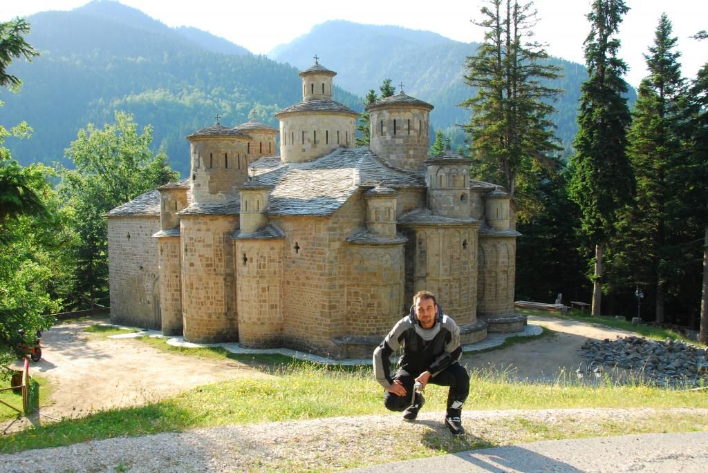
9. Taygetos Pass Roads
Google Maps:
a. Μεγαλόπολη - Γύθειο μέσω Γεωργίτσι,
b. Σπάρτη - Καλαμάτα,
c. Καλαμάτα - Ακρωτήρι Ταίναρον
Geographical region: Πελοπόννησος, Όρος Ταϋγετος
Photo Διαδρομής:
10. Ηλεία, Ορεινή Αρκαδία (επιμέρους διαδρομές: Πύργος - Μεγαλόπολη, Βυτίνα - Αρχαία Ολυμπία μέσω Λαγκάδια, Ελληνικό - Πλατανιά μέσω Ανδρίτσαινας)
Geographical region: Κεντρική Δυτική Πελοπόννησος, Νομός Ηλείας, Αρκαδίας (Όρος Μαίναλο)

Video by vstromkiller (Λιμπόβισι - Καρύταινα)
11. Δράμα - Καράντερε - Φρακτός - Παρανέστι
Geographical region: Μακεδονία, Δράμα


12. Θίσβη - Επτάλοφος (Αγόριανη) - Παύλιανη - Αθ. Διάκος - Κροκύλειο - Ελάτου - Αρτοτίνα
Geographical region: Στερεά Ελλάδα, Όρη Παρνασσός, Βαρδούσια, Γκιώνα

13. Καρπενήσι All around (επιμέρους διαδρομές: Καρπενήσι - Φουρνά, Πέρασμα Καρπενησίου, Καρπενήσι - Μεγάλο Χωριό)
Geographical region: Στερεά Ελλάδα, Νομός Ευρυτανίας

Video by Morniac για το πέρασμα Καρπενησίου:
14. Χαλκιδική ο γύρος του 2ου ποδιού
Geographical region: Μακεδονία, Χαλκιδική, Χερσόνησος της Σιθωνίας


15. Νάουσα - 3 5 Πηγάδια - Ξηρολίβαδο
Geographical region: Μακεδονία, Όρος Βέρμιο
Photo Διαδρομής:
Video by Morniac (διαδρομή πριν το Σελι απο Ξηρολιβαδο)
16. Ο Γύρος των Αγράφων
Geographical region: Στερεά Ελλάδα - Θεσσαλία, Οροσειρά Άγραφα


17. Κορωνησία
Geographical region: Νότια Ήπειρος, Άρτα


18. Κίσαβος
Geographical region: Θεσσαλία, Όρος Κίσαβος (Όσσα)


19. Όλυμπος
Geographical region: Μακεδονία - Θεσσαλία, Όρος Όλυμπος
Photo Διαδρομής:
20.
21.
22.
Το λοιπόν.... συγκεντρώνω υλικό για να γίνει μια σωστή παρουσίαση και να μεταφραστεί στα αγγλικά. Στην συνέχεια θα τοποθετηθεί στο international section για να πληροφορήσουμε και τους εκεί φίλους μας. Η λίστα είναι δυναμική και διαμορφώνεται με την συμμετοχή όλων μας.
Θα ήθελα τουλάχιστον μια φωτογραφία δρόμου από κάθε διαδρομή και τον χάρτη της διαδρομής σε google maps. Προαιρετικά, μιας και δύσκολο να βρεθεί για όλες τις διαδρομές, είναι το video.
Ακόμα καλό είναι να αναφερθούν λίγα λόγια γιατί αξίζει κάποιος να κάνει μια συγκεκριμένη διαδρομή. Πέρα από στοιχεία της ίδιας της διαδρομής που της δίνουν μοναδικότητα και την ξεχωρίζουν μπορούν να αναφερθούν και σημεία άξια προσοχής του στυλ "Αξίζει να δεις". Ενδεικτικά αναφέρω:
Ένα γραφικό χωριουδάκι, ένα φαράγγι, ένα πέτρινο γεφύρι, μιας ιστορικής αξίας τοποθεσία, ένα μνημείο, ένας καταρράκτης, μια λίμνη, ένας βιότοπος, μια παραλία, ένα ιδανικό μέρος για κατασκήνωση/διανυκτέρευση ή φαγητό/cafe, ένα μονοπάτι, ένα άκρο, ένα πάσο και αρκετά άλλα... είναι αυτά που συμπληρώνουν μια διαδρομή και την κάνουν ακόμα πιο ενδιαφέρουσα και αξιομνημόνευτη. Απλές αναφορές χωρίς φώτο όμως, γιατί δεν θέλουμε να πλατιάσει το θέμα (ιδανικά: ονομασία σημείου, που βρίσκεται στην διαδρομή μας και ένα link με περισσότερες πληροφορίες πχ από wikipedia ή κάποιον άλλο οδηγό). Τέλος καλό είναι να προστεθούν πληροφορίες για προσοχή ή αποφυγή των διαδρομών (πχ λόγω εποχικότητας, έργων ή κάτι άλλο).
Οποιαδήποτε παρατήρηση δεκτή... προτείνετε άλλους τίτλους διαδρομών, άλλες φωτογραφίες, διορθώστε τυχών λάθη κλπ.
We love travelling, and definitely we love traveling by motorcycle. We enjoy riding through beautiful vistas and landscapes. We love the freedom and how connected we feel to our surroundings on a bike. Once you've started discovering new places/people/cultures on two wheels, adds an existential dimension to yourbeing-in-the-world and opens a new horizon in the inner temporality.
Greece is among the favorite motorcycle destinations for a good reason. This unique, mountainous, peninsular offers a great diversity of beautiful paths. Every corner leads to a new experience. Ideal for motorcycle riders who are avoiding flat highways and searching scenic roads to allow them access to the most remote locations.
Here is a small list of selected routes that may help you organize your trip. The list is indicative and is only used for sharing information by fellow motorcyclists who have travelled all over the country and think of these routes as the most notable. Think of it more as a starting point than anything else and make your personal adjustments according to your own travelling plans and needs. Every route has a road photograph and a google map's link. In some routes video footages are included as well. Few comments about the routes will be added in the future including some points of interest such as old bridges, canyons, traditional settlements, historical monuments etc. This is an open list after all and you are free to comment or propose modifications.
Few words about the country.
In English it is referred to as Greece but locals call the country Hellas or Ellada. Located strategically in Southern Europe at the crossroads of Europe, Asia, and Africa. Greece consists of a mountainous, peninsular mainland jutting out into the sea at the southern end of the Balkans, ending at the Peloponnese peninsula (separated from the mainland by the canal of the Isthmus of Corinth). Eighty percent of Greece consists of mountains, of which Mount Olympus, the mythical abode of the Greek Gods, is the highest, at 2,917 m (9,570 ft).
Mainland contains a number of lakes and wetlands and is dominated by the Pindus mountain range. The Pindus range continues through the central Peloponnese. This vast complex of mountains, peaks, plateaus, valleys and gorges traverses the Greek mainland from the Northwest to the Southeast. Its length reaches almost 230 kilometers and its largest width is 70 kilometers. Pindus is characterized by its high, steep peaks, often dissected by numerous canyons and a variety of other karstic landscapes.
Also, Greece has the longest coastline on the Mediterranean Basin and features a vast number of islands. Crete is the largest and the most populous island; Euboea, separated from the mainland by the 60m-wide Euripus Strait, is the second largest.
Climate
The country has considerable climatic variation. It is primarily Mediterranean, featuring mild, wet winters and hot, dry summers. The Pindus mountain range strongly affects the climate of the country, as areas to the west of the range are considerably wetter on average than the areas lying to the east of the range. The mountainous areas of Northwestern Greece as well as in the mountainous central parts of Peloponnese feature an Alpine climate with snowfalls during the winter.
History
Greece has a rich legacy and traces its roots to the civilization of Ancient Greece. This is partly reflected by the 17 UNESCO World Heritage Sites located in Greece, ranking it 6th in Europe and 13th in the world.
...
Το top μέχρι στιγμής με το υλικό που υπάρχει (θα ενημερώνεται κάθε φορά που θα προστίθεται κάτι νέο):
1. Baros Pass
Google Map: Ανήλιο - Χαλίκι - Μπάρος - Καλαρρύτες - Μονή Κηπίνας - Κέδρος - Ιωάννινα (Χαρακόπι)
Geographical region: Kalarites Zone, Epirus, Ioannina, Mt Athamanika or Tzoumerka
The Baros Pass is a spectacular high mountain road, reaching the top of the pass, at an elevation of 1,905m above the sea level, located on the Kalarites zone.
The pass is being improved the last years, with some asphalt works. This road is usually open all year, but it can be closed when the access is not cleared of snow.
The road includes some steep sections, without market central lines, very narrow, impassable for 2 cars at the same time and without protections and guardrails.
From Anilio to Chaliki the road is narrow with paved surface in a rather bad shape in some points. However the scenery is astonishing as the road winds through a beautiful forest in the most part, reaching at the altitude of 1600 m. where the alpine scenery takes place and gets spectacular. After about 7km from Chaliki village (alt 1100m) the road is forked (turn on the right to continue your trip through the Baros pass). In 2km from the junction you can stop to the monastery of “Panagia Galaktotrofousa” and enjoy the view. From this point and for the rest 1750m starts a twisty roller coaster, which no doubt will blow you away. Always watch for loose gravel and especially the last 200m. For the next 10km you are moving on a much slower pace because of the condition of the road until you reach at Kalarites village where you can stop for a hot coffee or a goody. You continue to ride downhill until you reach to the iron bridge. Next to it you will find the old stone bridge of “Filou” or “Tortouri”. After about a kilometer as you will pass a dark tunnel you will reach to the old monastery of “Kipinas” (1204) built in the rock. A stop and a tour in the interior are highly recommended.
Video by ckalfas:
Points of interest:
- Anilio Metsovou (village alt. 1060)
- Anthousa Panagia Galaktotrofousa (chapel)
- Chaliki Trikalon (village alt. 1160)
- Kalarites (village alt. 1120)
- Stone bridge "Filou" or "Tourtouri"
- Iera Moni Kipinas (Monaster)
2. Kefalonia Ionian Island
Google Map: Κεφαλλονιά από την παραλία του Μυρτου έως τον Ασσο μέσα από το βουνό
Geographical region: Ionian Islands, Kefallonia
Cephalonia or Kefalonia, is the largest of the Ionian Islands in western Greece.
You don't want to miss Kefalonia’s Magnificent Scenic Drive. Kefalonia, by its nature, is a mountainous island and therefore, many of its roads, whether coastal or inland, will have some bends, gradients and drop offs to one side or the other. The road through the mountain has excellent barriers all along it and it isn't very narrow. The traffic isnt busy either. Take your time, stop often for the views and enjoy. Be carefull about rockfalls or passing goats.
Points of interest:
- Myrtos Beach (http://en.wikipedia.org/wiki/Myrtos_Beach)
- Assos (coastal village)
3. Καλαμπάκα - Περτούλι - Πύλι
Google Map: Καλαμπάκα (Μετέωρα) - Μονή Τιμίου Σταυρού - Περτούλι - Πύλη
Geographical region: Θεσσαλία, Πίνδος, ΝομόςΤρικάλων
Photo Διαδρομής:
4. Kallikrate's Pass and Aradena Gorge
Google Map: "Πέρασμα του Καλλικράτη" και Φαράγγι Αράδενας
Geographical region: Crete Island, White Mountains, Chania
The road between Kallikratis and Kapsodasos is a sharply winding and precipitous ascent in a a steep and narrow zig-zag road in southwest Crete, Greece.
The intresting part of the road (11km long) starts in Kalikratis, a small mountainous village in Sfakia municipality, southwest Crete, at the foot of the White Mountains (Lefka Ori) at an altitude of 750m above sea level and .
The road was asphalted in 2006 but it's very narrow. The recently paved road that runs through Kalikratis gorge is scary bumpy, small and empty, without barriers but with great views of Libyan (Southern Cretan) Sea.
Video by yns:
Points of interest:
- Aradena Gorge
- Bridge Vardinogiannis (the 2nd highest bridge for bungee jumping in Europe)
5. Ο γύρος της Θάσου
Geographical region: Ανατολική Μακεδονία, Νήσος Θάσος
Video by Παναγιώτης Κ.
6. Ο γύρος το Πάρνωνα
Google Map: https://goo.gl/maps/dBnCl
Geographical region: Πελοπόννησος, Όρος Πάρνωνας
7. Πάπιγγο - Σαμαρίνα - Γρεβενά - Τσοτύλι - Δροτσικό - Επταχώρι - Νεστόριο
Geographical region: Πίνδος, Όρη Τύμφη & Βέρμιο
Video by Morniac
8. Πήλιο "ο μεγάλος γύρος" Πορταριά - Μούρεσι - Τσαγκαράδα - Μηλιές - Αγριά
Geographical region: Θεσσαλία, Όρος Πήλιο
9. Taygetos Pass Roads
Google Maps:
a. Μεγαλόπολη - Γύθειο μέσω Γεωργίτσι,
b. Σπάρτη - Καλαμάτα,
c. Καλαμάτα - Ακρωτήρι Ταίναρον
Geographical region: Πελοπόννησος, Όρος Ταϋγετος
Photo Διαδρομής:
10. Ηλεία, Ορεινή Αρκαδία (επιμέρους διαδρομές: Πύργος - Μεγαλόπολη, Βυτίνα - Αρχαία Ολυμπία μέσω Λαγκάδια, Ελληνικό - Πλατανιά μέσω Ανδρίτσαινας)
Geographical region: Κεντρική Δυτική Πελοπόννησος, Νομός Ηλείας, Αρκαδίας (Όρος Μαίναλο)
Video by vstromkiller (Λιμπόβισι - Καρύταινα)
11. Δράμα - Καράντερε - Φρακτός - Παρανέστι
Geographical region: Μακεδονία, Δράμα
12. Θίσβη - Επτάλοφος (Αγόριανη) - Παύλιανη - Αθ. Διάκος - Κροκύλειο - Ελάτου - Αρτοτίνα
Geographical region: Στερεά Ελλάδα, Όρη Παρνασσός, Βαρδούσια, Γκιώνα
13. Καρπενήσι All around (επιμέρους διαδρομές: Καρπενήσι - Φουρνά, Πέρασμα Καρπενησίου, Καρπενήσι - Μεγάλο Χωριό)
Geographical region: Στερεά Ελλάδα, Νομός Ευρυτανίας
Video by Morniac για το πέρασμα Καρπενησίου:
14. Χαλκιδική ο γύρος του 2ου ποδιού
Geographical region: Μακεδονία, Χαλκιδική, Χερσόνησος της Σιθωνίας
15. Νάουσα - 3 5 Πηγάδια - Ξηρολίβαδο
Geographical region: Μακεδονία, Όρος Βέρμιο
Photo Διαδρομής:
Video by Morniac (διαδρομή πριν το Σελι απο Ξηρολιβαδο)
16. Ο Γύρος των Αγράφων
Geographical region: Στερεά Ελλάδα - Θεσσαλία, Οροσειρά Άγραφα
17. Κορωνησία
Geographical region: Νότια Ήπειρος, Άρτα
18. Κίσαβος
Geographical region: Θεσσαλία, Όρος Κίσαβος (Όσσα)
19. Όλυμπος
Geographical region: Μακεδονία - Θεσσαλία, Όρος Όλυμπος
Photo Διαδρομής:
20.
21.
22.
Το λοιπόν.... συγκεντρώνω υλικό για να γίνει μια σωστή παρουσίαση και να μεταφραστεί στα αγγλικά. Στην συνέχεια θα τοποθετηθεί στο international section για να πληροφορήσουμε και τους εκεί φίλους μας. Η λίστα είναι δυναμική και διαμορφώνεται με την συμμετοχή όλων μας.
Θα ήθελα τουλάχιστον μια φωτογραφία δρόμου από κάθε διαδρομή και τον χάρτη της διαδρομής σε google maps. Προαιρετικά, μιας και δύσκολο να βρεθεί για όλες τις διαδρομές, είναι το video.
Ακόμα καλό είναι να αναφερθούν λίγα λόγια γιατί αξίζει κάποιος να κάνει μια συγκεκριμένη διαδρομή. Πέρα από στοιχεία της ίδιας της διαδρομής που της δίνουν μοναδικότητα και την ξεχωρίζουν μπορούν να αναφερθούν και σημεία άξια προσοχής του στυλ "Αξίζει να δεις". Ενδεικτικά αναφέρω:
Ένα γραφικό χωριουδάκι, ένα φαράγγι, ένα πέτρινο γεφύρι, μιας ιστορικής αξίας τοποθεσία, ένα μνημείο, ένας καταρράκτης, μια λίμνη, ένας βιότοπος, μια παραλία, ένα ιδανικό μέρος για κατασκήνωση/διανυκτέρευση ή φαγητό/cafe, ένα μονοπάτι, ένα άκρο, ένα πάσο και αρκετά άλλα... είναι αυτά που συμπληρώνουν μια διαδρομή και την κάνουν ακόμα πιο ενδιαφέρουσα και αξιομνημόνευτη. Απλές αναφορές χωρίς φώτο όμως, γιατί δεν θέλουμε να πλατιάσει το θέμα (ιδανικά: ονομασία σημείου, που βρίσκεται στην διαδρομή μας και ένα link με περισσότερες πληροφορίες πχ από wikipedia ή κάποιον άλλο οδηγό). Τέλος καλό είναι να προστεθούν πληροφορίες για προσοχή ή αποφυγή των διαδρομών (πχ λόγω εποχικότητας, έργων ή κάτι άλλο).
Οποιαδήποτε παρατήρηση δεκτή... προτείνετε άλλους τίτλους διαδρομών, άλλες φωτογραφίες, διορθώστε τυχών λάθη κλπ.
Τελευταία επεξεργασία: